Comprehensive Land Use Plan
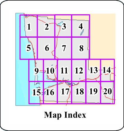
Designation Maps
Map 1: Quinault Indian Reservation
Map 2: Quinault Indian Reservation
Map 3: Olympic National Forest and Lake Quinault
Map 3A: Blow-up #1 – Quinault and Taholah
Map 4: Olympic National Forest and Olympic National Park
Map 5: Moclips, Pacific Beach and Seabrook
Map 5A: Blow-up #2 – Pacific Beach
Map 6: Humptulips and Axford Prairie
Map 7: North Wishkah
Map 8: North Wynoochee Valley
Map 9: Copalis Beach, Hogans Corner, Ocean City, and Oyehut
Map 9A: Blow-up #3 – Copalis Beach
Map 10: Copalis Crossing, Wilderness, Tulips, Burrows, New London, Chenois Creek and Grays Harbor City
Map 11: Wishkah, Aberdeen Gardens and Nisson
Map 12: Montesano, Central Park and Brady
Map 13: Brady, Satsop and Elma
Map 14: McCleary and Capital State Forest
Map 15: Ocosta, Bay City and Grayland
Map 16: Markham, Western, Ocosta and Bay City
Map 17: Newskah, Cosmopolis, Junction City, Artic and Central Park
Map 18: Central Park, Montesano, Melbourne, Artic and Vesta
Map 19: Fuller, Saginaw, Malone, Porter, Lankner, Cederville and Lower Chehalis State Forest
Map 20: Malone, Porter, Lankner, Oakville, Capitol State Forest, Lower Chehalis State Forest and Chehalis Indian Reservation
Land Use Designation Descriptions
The following describe the activities and residential densities that correspond to the land use designations shown on the maps.
Agricultural Resource
Agricultural resource designation preserves and promotes the commercial production of horticulture, viticulture, floriculture, dairy, apiary, vegetable, and animal products, or the food and fiber for the consumption of livestock, and other products, processes and facilities normally associated with farming. In addition to agricultural production, this designation allows secondary uses that support the economic viability of farms such as farmworker housing, production and sales of value-added agricultural products, agricultural tourism such as farm tours and u-pick, and small-scale events such as farm to table dinners. Residential density ranges from 1 dwelling unit per 20 acres or larger to 1 dwelling unit per 10 acres.
Agricultural Overlay
Areas that meet the existing designation criteria for agricultural resource lands contained in Grays Harbor County Code Chapter 18.10. These properties are eligible for the Agricultural Resource designation and associated zoning.
General Development
General development provides for rural lifestyles on lots five acres or larger in areas with limited infrastructure or with natural hazards or environmentally critical areas. Primary uses include residential, agricultural, forestry and small-scale commercial uses. Residential density range is one dwelling unit per 5 acres or larger.
Lake Quinault
The Lake Quinault designation encompasses the entire planning area associated with Lake Quinault. It recognizes a broad mix of land uses distributed throughout the four unincorporated communities of Neilton, Amanda Park, North Shore, and South Shore. Uses include residential, commercial, manufacturing, public, and resource-based activities. Residential density range is up to 7.5 dwelling units per acre.
Mixed Use
Mixed Use designation is intended to serve as the major centers of rural commercial activity and residential development in the unincorporated county. These areas are served by public water and wastewater systems and characterized by an existing mix of residential, commercial and tourist serving uses. Residential density range is 1 dwelling unit per acre to 20 dwelling units per acre.
Rural Development
Rural development recognizes concentrations of small-scale commercial uses and residential areas developed with lot sizes averaging less than five acres. In some cases they include public uses such as a fire hall or post office. Typically, they are located at crossroads of county roads, state routes, or major arterials. They are smaller in size and intensity than Mixed Use and are intended to help meet existing and future commercial needs of the larger surrounding neighborhood. Areas such as Humptulips, Porter and Malone are examples of Rural Development areas. Residential densities range from one dwelling unit per 5 acres to one dwelling unit per acre.
Rural Industrial
Rural Industrial is intended to support the production of agricultural, forest, and aquatic products by allowing processing facilities, limited direct resource sales, and limited natural resource support services. Examples of typical uses include saw-mills, agricultural or forest industry equipment maintenance, agricultural processing plants, and seafood processing and on-site sales.
Rural Residential
The rural residential designation allows for a variety of residential densities while protecting rural lifestyles. The rural residential designation recognizes existing predominantly residential neighborhoods developed with lot-sizes of less than five acres that are supported by public services and facilities including roads, fire districts, schools, public or private water systems and other utilities. Rural residential areas are located to minimize conflicts with agricultural, mineral, forest, rural industrial uses and hazardous areas. Residential density range is 1 dwelling unit per acre to 6 dwelling units per acre.
Satsop Development Park
The Satsop Development Park provides economic opportunities and jobs in an ecologically sensitive way, while balancing economic development with environmental protection, habitat conservation and sustainable forest management. It serves as a regionally significant employment and industrial center for the county with a wide range of industrial, technology and office uses in a master planned setting. The designation includes both developed employment areas and surrounding multi-use lands that support infrastructure, forest management, habitat conservation, and recreational uses. Secondary uses include forestry, parks, open space, recreation, and public educational uses. Development and land use within the Park are guided by the Satsop Development Park Master Plan.
Urban Services
The urban services designation is intended to provide centers for commercial, services, industrial and residential uses within City utility service areas. Development within the urban services designation requires interjurisdictional coordination to ensure that development is timed, phased and designed consistent with City planned uses, densities and infrastructure standards. Residential density range is 1 dwelling unit per acre to 20 dwelling units per acre.
Copyright Grays Harbor County Comprehensive Land Use Plan 2027. All Rights Reserved.
Hosted By